

Clarenville 🇨🇦
-
Nautical Twilight begins:04:15 amSunrise:05:35 am
-
Sunset:08:30 pmNautical Twilight ends:09:50 pm
-
Moonrise:03:27 pm
-
Moonset:03:45 am
-
Moon over:10:09 pm
-
Moon under:09:36 am
-
Visibility:78%
-
 Waxing Gibbous
-
Distance to earth:399,380 kmProximity:14.8 %
Moon Phases for Clarenville
-
poor Day
-
minor Time:02:45 am - 04:45 am
-
major Time:08:36 am - 10:36 am
-
minor Time:02:27 pm - 04:27 pm
-
major Time:09:09 pm - 11:09 pm
Tide Clock
Tide Graph
Times
| Tide | Time | Height |
|---|---|---|
| high | 04:57 am | 2.89 ft |
| low | 10:55 am | 1.25 ft |
| high | 05:29 pm | 2.66 ft |
| low | 11:37 pm | 1.51 ft |
| Date | Major Bite Times | Minor Bite Times | Sun | Moon | Moonphase | Tide Times |
|---|---|---|---|---|---|---|
|
Wed, 07 May
|
08:36 am -
10:36 am
09:09 pm -
11:09 pm
|
02:45 am -
04:45 am
02:27 pm -
04:27 pm
|
R: 05:35 am S: 08:30 pm |
R: 03:27 pm S: 03:45 am |
Waxing Gibbous |
high: 04:57 am
, 2.89 ft
, Coeff: 64
low: 10:55 am
, 1.25 ft
high: 05:29 pm
, 2.66 ft
, Coeff: 53
low: 11:37 pm
, 1.51 ft
|
|
Thu, 08 May
|
09:15 am -
11:15 am
09:49 pm -
11:49 pm
|
02:57 am -
04:57 am
03:33 pm -
05:33 pm
|
R: 05:34 am S: 08:31 pm |
R: 04:33 pm S: 03:57 am |
Waxing Gibbous |
high: 05:43 am
, 2.92 ft
, Coeff: 66
low: 11:37 am
, 1.12 ft
high: 06:11 pm
, 2.85 ft
, Coeff: 63
|
|
Fri, 09 May
|
09:55 am -
11:55 am
10:29 pm -
12:29 am
|
03:10 am -
05:10 am
04:40 pm -
06:40 pm
|
R: 05:32 am S: 08:32 pm |
R: 05:40 pm S: 04:10 am |
Waxing Gibbous |
low: 12:19 am
, 1.21 ft
high: 06:22 am
, 2.92 ft
, Coeff: 66
low: 12:13 pm
, 0.98 ft
high: 06:48 pm
, 3.08 ft
, Coeff: 74
|
|
Sat, 10 May
|
10:35 am -
12:35 pm
11:10 pm -
01:10 am
|
03:23 am -
05:23 am
05:47 pm -
07:47 pm
|
R: 05:31 am S: 08:34 pm |
R: 06:47 pm S: 04:23 am |
Waxing Gibbous |
low: 12:54 am
, 0.95 ft
high: 07:00 am
, 2.89 ft
, Coeff: 64
low: 12:50 pm
, 0.85 ft
high: 07:21 pm
, 3.25 ft
, Coeff: 82
|
|
Sun, 11 May
|
11:18 am -
01:18 pm
10:43 pm -
12:43 am
|
03:39 am -
05:39 am
06:57 pm -
08:57 pm
|
R: 05:29 am S: 08:35 pm |
R: 07:57 pm S: 04:39 am |
Full Moon |
low: 01:28 am
, 0.72 ft
high: 07:36 am
, 2.82 ft
, Coeff: 61
low: 01:27 pm
, 0.79 ft
high: 07:53 pm
, 3.41 ft
, Coeff: 90
|
|
Mon, 12 May
|
12:02 pm -
02:02 pm
11:28 pm -
01:28 am
|
03:58 am -
05:58 am
08:07 pm -
10:07 pm
|
R: 05:28 am S: 08:37 pm |
R: 09:07 pm S: 04:58 am |
Full Moon |
low: 02:03 am
, 0.56 ft
high: 08:12 am
, 2.79 ft
, Coeff: 59
low: 02:04 pm
, 0.72 ft
high: 08:23 pm
, 3.51 ft
, Coeff: 95
|
|
Tue, 13 May
|
12:16 am -
02:16 am
12:49 pm -
02:49 pm
|
04:23 am -
06:23 am
09:15 pm -
11:15 pm
|
R: 05:27 am S: 08:38 pm |
R: 10:15 pm S: 05:23 am |
Full Moon |
low: 02:39 am
, 0.46 ft
high: 08:48 am
, 2.72 ft
, Coeff: 56
low: 02:41 pm
, 0.72 ft
high: 08:50 pm
, 3.61 ft
, Coeff: 100
|
")


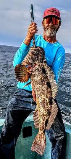
uploaded by: Brad Kleinow

uploaded by: Brad Kleinow

uploaded by: Joey Piercefield

uploaded by: Joey Piercefield

uploaded by: Joey Piercefield

uploaded by: Joey Piercefield

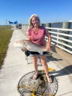
uploaded by: Jeanette Prince

uploaded by: Boojo

uploaded by: jennifer baldwin

uploaded by: jennifer baldwin
Best Fishing Spots in the greater Clarenville area
Beaches and Bays are ideal places for land-based fishing. If the beach is shallow and the water is clear then twilight times are usually the best times, especially when they coincide with a major or minor fishing time. Often the points on either side of a beach are the best spots. Or if the beach is large then look for irregularities in the breaking waves, indicating sandbanks and holes. We found 2 beaches and bays in this area.
Red Beach - 2km , Camp Pond - 15km
Harbours and Marinas can often times be productive fishing spots for land based fishing as their sheltered environment attracts a wide variety of bait fish. Similar to river mouths, harbour entrances are also great places to fish as lots of fish will move in and out with the rising and falling tides. There are 6 main harbours in this area.
Shoal Harbour - 2km, Clarenville-Shoal Harbour - 2km, Lower Shoal Harbour - 2km, Snooks Harbour Pond - 5km, Snooks Harbour - 6km, Shoal Harbour Pond - 14km
We found a total of 84 potential fishing spots nearby Clarenville. Below you can find them organized on a map. Points, Headlands, Reefs, Islands, Channels, etc can all be productive fishing spots. As these are user submitted spots, there might be some errors in the exact location. You also need to cross check local fishing regulations. Some of the spots might be in or around marine reserves or other locations that cannot be fished. If you click on a location marker it will bring up some details and a quick link to google search, satellite maps and fishing times. Tip: Click/Tap on a new area to load more fishing spots.
Dark Hole - 0km , Bounds Mead - 1km , Red Point - 1km , Strongs Point - 1km , Shoal Harbour - 2km , Clarenville-Shoal Harbour - 2km , Bullocks Point - 2km , Horsestinger Point - 2km , Man Point - 2km , Red Beach - 2km , Lower Shoal Harbour - 2km , Aspey Point - 4km , Summers Pond - 4km , Bar Mead - 4km , Bluff Point - 5km , Elliotts Cove Pond - 5km , Snooks Harbour Pond - 5km , Deep Bight Pond - 6km , Brickyard Point - 6km , Grindstone Head - 6km , Gooseberry Point - 6km , Snooks Harbour - 6km , Sandy Point - 7km , Pittman Point - 7km , Birchy Point - 7km , Fosters Point - 8km , Loon Pond - 9km , Pie Duck Pond - 9km , Eatons Pond - 9km , Bald Nap Pond - 9km , Island Pond - 9km , Smith Point - 9km , Big Pond - 10km , Rocky Pond - 10km , First Pond - 10km , Bald Nap Point - 10km , Lily Pond - 10km , Long Pond - 10km , Goose Pond - 11km , Second Pond - 11km , Claude Pond - 11km , Little Marsh Pond - 11km , Bugden Pond - 11km , Gulliford Pond - 11km , Whale Back Pond - 11km , Fagans Pond - 11km , Tug Pond - 12km , Hornet Pond - 12km , Hideaway Pond - 12km , Daltons Head - 12km , Figure-Eight Pond - 12km , Georges Pond - 13km , Jessies Pond - 13km , Sandy Pond - 13km , Upper Gull Pond - 13km , Aspey Cove Pond - 13km , Bluff Head Big Pond - 13km , Double Pond - 13km , Nine Island Pond - 13km , Shoal Harbour Pond - 14km , Gull Pond - 14km , Churchill Pond - 14km , Cooper Pond - 14km , Lady Point - 14km , Oats Pond - 14km , Andrews Pond - 15km , Camp Pond - 15km , Lois Lake - 15km , Moody Pond - 15km , Muskrat Pond - 16km , Terrances Pond - 16km , Blood Pond - 16km , Trout Pond - 16km , Big Drake Pond - 16km , Wolf Point Pond - 16km , Beaver Pond - 16km , Valley Pond - 16km , Anglo Water Pond - 16km , Crow Cliff Point - 16km , Tolt Point - 16km , Grassey Pond - 17km , Salt Lake Steadies - 17km , Odies Pond - 17km , Red Pond - 17km
Comments