
Río Gatún 🇵🇦
-
Nautical Twilight begins:05:24 amSunrise:06:09 am
-
Sunset:06:27 pmNautical Twilight ends:07:12 pm
-
Moonrise:04:15 pm
-
Moonset:03:14 am
-
Moon over:10:08 pm
-
Moon under:09:44 am
-
Visibility:89%
-
 Waxing Gibbous
-
Distance to earth:388,356 kmProximity:40.7 %
Moon Phases for Río Gatún
-
poor Day
-
minor Time:02:14 am - 04:14 am
-
major Time:08:44 am - 10:44 am
-
minor Time:03:15 pm - 05:15 pm
-
major Time:09:08 pm - 11:08 pm
Tide Clock
Tide Graph
Times
| Tide | Time | Height |
|---|---|---|
| low | 04:47 am | -0.03 ft |
| high | 09:48 am | 0.23 ft |
| low | 01:21 pm | 0.13 ft |
| high | 09:22 pm | 1.15 ft |
| Date | Major Bite Times | Minor Bite Times | Sun | Moon | Moonphase | Tide Times |
|---|---|---|---|---|---|---|
|
Thu, 04 Sep
|
08:44 am -
10:44 am
09:08 pm -
11:08 pm
|
02:14 am -
04:14 am
03:15 pm -
05:15 pm
|
R: 06:09 am S: 06:27 pm |
R: 04:15 pm S: 03:14 am |
Waxing Gibbous |
low: 04:47 am
, -0.03 ft
high: 09:48 am
, 0.23 ft
, Coeff: -22
low: 01:21 pm
, 0.13 ft
high: 09:22 pm
, 1.15 ft
, Coeff: 212
|
|
Fri, 05 Sep
|
09:35 am -
11:35 am
09:58 pm -
11:58 pm
|
03:09 am -
05:09 am
04:02 pm -
06:02 pm
|
R: 06:09 am S: 06:26 pm |
R: 05:02 pm S: 04:09 am |
Waxing Gibbous |
low: 05:23 am
, 0 ft
high: 10:37 am
, 0.26 ft
, Coeff: -13
low: 02:16 pm
, 0.16 ft
high: 10:05 pm
, 1.05 ft
, Coeff: 187
|
|
Sat, 06 Sep
|
10:26 am -
12:26 pm
10:48 pm -
12:48 am
|
04:04 am -
06:04 am
04:48 pm -
06:48 pm
|
R: 06:09 am S: 06:26 pm |
R: 05:48 pm S: 05:04 am |
Full Moon |
low: 05:54 am
, 0.03 ft
high: 11:32 am
, 0.36 ft
, Coeff: 12
low: 03:35 pm
, 0.23 ft
high: 10:55 pm
, 0.92 ft
, Coeff: 153
|
|
Sun, 07 Sep
|
11:14 am -
01:14 pm
10:52 pm -
12:52 am
|
04:57 am -
06:57 am
05:31 pm -
07:31 pm
|
R: 06:09 am S: 06:25 pm |
R: 06:31 pm S: 05:57 am |
Full Moon |
low: 06:22 am
, 0.07 ft
high: 12:28 pm
, 0.49 ft
, Coeff: 45
low: 05:24 pm
, 0.3 ft
high: 11:55 pm
, 0.79 ft
, Coeff: 120
|
|
Mon, 08 Sep
|
12:02 pm -
02:02 pm
11:39 pm -
01:39 am
|
05:50 am -
07:50 am
06:15 pm -
08:15 pm
|
R: 06:09 am S: 06:25 pm |
R: 07:15 pm S: 06:50 am |
Full Moon |
low: 06:50 am
, 0.1 ft
high: 01:21 pm
, 0.69 ft
, Coeff: 95
low: 07:24 pm
, 0.26 ft
|
|
Tue, 09 Sep
|
12:28 am -
02:28 am
12:52 pm -
02:52 pm
|
06:45 am -
08:45 am
07:00 pm -
09:00 pm
|
R: 06:08 am S: 06:24 pm |
R: 08:00 pm S: 07:45 am |
Waning Gibbous |
high: 01:10 am
, 0.62 ft
, Coeff: 78
low: 07:20 am
, 0.13 ft
high: 02:11 pm
, 0.85 ft
, Coeff: 137
low: 09:07 pm
, 0.13 ft
|
|
Wed, 10 Sep
|
01:17 am -
03:17 am
01:43 pm -
03:43 pm
|
07:40 am -
09:40 am
07:47 pm -
09:47 pm
|
R: 06:08 am S: 06:23 pm |
R: 08:47 pm S: 08:40 am |
Waning Gibbous |
high: 02:36 am
, 0.49 ft
, Coeff: 45
low: 07:54 am
, 0.16 ft
high: 03:00 pm
, 1.05 ft
, Coeff: 187
low: 10:24 pm
, -0 ft
|


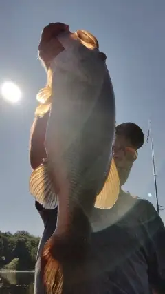
uploaded by: Steven Butcheck

uploaded by: Joey Piercefield

uploaded by: Hoza

uploaded by: John Matthews

uploaded by: JoEllen Disterhaupt

uploaded by: JoEllen Disterhaupt

uploaded by: Charlie Pifer

uploaded by: Charlie Pifer

uploaded by: Charlie Pifer

uploaded by: Charlie Pifer
Gatun,Rio Gatun,Río Gatún
Best Fishing Spots in the greater Río Gatún area
We found a total of 100 potential fishing spots nearby Río Gatún. Below you can find them organized on a map. Points, Headlands, Reefs, Islands, Channels, etc can all be productive fishing spots. As these are user submitted spots, there might be some errors in the exact location. You also need to cross check local fishing regulations. Some of the spots might be in or around marine reserves or other locations that cannot be fished. If you click on a location marker it will bring up some details and a quick link to google search, satellite maps and fishing times. Tip: Click/Tap on a new area to load more fishing spots.
Isla Salud - 3km , Isla Alfajía - 4km , Isla Patos - 4km , Tapir Key - 5km , Isla Sorrel - 5km , Isla Redondo - 5km , Isla Dos Huevos - 5km , Isla Bovales - 6km , Gusanillo Island - 6km , Isla Anote - 7km , Isla Arena - 7km , Isla Babbitt - 7km , Isla Terapa - 7km , Isla López - 7km , Isla Níspero - 7km , Isla Nance - 7km , Yampi Island - 8km , Isla Brazo - 8km , Isla Carlos José - 8km , Isla San Martín - 8km , Salada Island - 8km , Isla Pomarosa - 8km , Isla Piña - 8km , Quebrada La Chinilla - 8km , Isla Papaya - 8km , Isla Limón - 8km , Isla Palma - 8km , Isla Mango - 8km , Isla Marañón - 8km , Isla Zorra - 9km , Isla Advenimiento - 9km , Isla Iglesia - 9km , Isla Lirio - 9km , Puente Bascute - 10km , Isla Quebrancha - 10km , Isla Egronal - 10km , Isla Iguana - 10km , Isla Pava - 10km , Isla Mesa Verde - 10km , Isla Banana - 11km , Isla Represa - 11km , Isla Piedras - 11km , Isla Cacao - 12km , Isla Caño Verde - 12km , Isla Serrano - 12km , Bahía Juan Gallegos - 12km , Isla Payardi - 12km , Ababa Island - 13km , Bahía Aojeta - 13km , Península Bohío - 13km , Isla Samba Bonita - 13km , Cuenca Salud - 13km , Don Pedro Island - 13km , Bahía Frijoles - 13km , Islas Juan Gallegos - 13km , Punta Payardi - 13km , Bahía Las Minas - 13km , Lindero Island - 13km , Vista Baja Island - 14km , Vista Alta Island - 14km , Isla Abogado - 14km , Isla Aojeta - 14km , Isla Buena Vista - 14km , Punta Buena Vista - 14km , Isla Covovi - 14km , Isla Droque - 14km , Isla Largo Remo - 14km , Isla Leonita - 14km , Punta Muerto - 14km , Punta Bohío - 15km , Isla Chicha - 15km , Coco Island - 15km , Coco Solo Point - 15km , Punta Colorado - 15km , Punta Salud - 15km , De Lesseps Island - 15km , Punta Frijoles - 15km , Isla Peina Guapa - 15km , Isla Lion Hill - 15km , Bahía de Manzanillo - 15km , Isla Orchid - 15km , Isla Mina - 15km , Canal Francés - 16km , Isla Balsa - 16km , Cabra Loma Island - 16km , Isla Dalia - 16km , Isla Frijolito - 16km , Isla Galeta - 16km , Isla Guanábano - 16km , Isla Guava - 16km , Isla Higuera - 16km , Isla Las Doncellas - 16km , Bahía de Margarita - 16km , Isla Margarita - 16km , Margarita Point - 16km , Stilsons Pond - 16km , Isla Naranjo Abajo - 16km , Isla Ocelote - 16km , Río Folk - 16km , Isla Naranjo Arriba - 16km
Comments