
Fort Hamer 🇺🇸
-
Nautical Twilight begins:05:52 amSunrise:06:46 am
-
Sunset:08:07 pmNautical Twilight ends:09:00 pm
-
Moonrise:02:14 pm
-
Moonset:02:57 am
-
Moon over:09:03 pm
-
Moon under:08:35 am
-
Visibility:61%
-
 First Quarter Moon
-
Distance to earth:391,820 kmProximity:32.6 %
Moon Phases for Fort Hamer
-
average Day
-
minor Time:01:57 am - 03:57 am
-
major Time:07:35 am - 09:35 am
-
minor Time:01:14 pm - 03:14 pm
-
major Time:08:03 pm - 10:03 pm
Tide Clock
Tide Graph
Times
| Tide | Time | Height |
|---|---|---|
| low | 04:34 am | 0 ft |
| high | 11:46 am | 1.38 ft |
| low | 03:40 pm | 1.38 ft |
| high | 08:49 pm | 1.74 ft |
| Date | Major Bite Times | Minor Bite Times | Sun | Moon | Moonphase | Tide Times |
|---|---|---|---|---|---|---|
|
Mon, 05 May
|
07:35 am -
09:35 am
08:03 pm -
10:03 pm
|
01:57 am -
03:57 am
01:14 pm -
03:14 pm
|
R: 06:46 am S: 08:07 pm |
R: 02:14 pm S: 02:57 am |
First Quarter Moon |
low: 04:34 am
, 0 ft
high: 11:46 am
, 1.38 ft
, Coeff: 51
low: 03:40 pm
, 1.38 ft
high: 08:49 pm
, 1.74 ft
, Coeff: 86
|
|
Tue, 06 May
|
08:19 am -
10:19 am
08:46 pm -
10:46 pm
|
02:29 am -
04:29 am
02:09 pm -
04:09 pm
|
R: 06:45 am S: 08:08 pm |
R: 03:09 pm S: 03:29 am |
Waxing Gibbous |
low: 05:19 am
, 0.2 ft
high: 11:44 am
, 1.48 ft
, Coeff: 61
low: 05:21 pm
, 1.12 ft
high: 10:26 pm
, 1.61 ft
, Coeff: 73
|
|
Wed, 07 May
|
08:59 am -
10:59 am
09:25 pm -
11:25 pm
|
02:57 am -
04:57 am
03:02 pm -
05:02 pm
|
R: 06:44 am S: 08:08 pm |
R: 04:02 pm S: 03:57 am |
Waxing Gibbous |
low: 05:54 am
, 0.39 ft
high: 11:53 am
, 1.61 ft
, Coeff: 73
low: 06:27 pm
, 0.79 ft
high: 11:44 pm
, 1.54 ft
, Coeff: 67
|
|
Thu, 08 May
|
09:38 am -
11:38 am
10:05 pm -
12:05 am
|
03:24 am -
05:24 am
03:53 pm -
05:53 pm
|
R: 06:44 am S: 08:09 pm |
R: 04:53 pm S: 04:24 am |
Waxing Gibbous |
low: 06:24 am
, 0.59 ft
high: 12:03 pm
, 1.74 ft
, Coeff: 86
low: 07:16 pm
, 0.49 ft
|
|
Fri, 09 May
|
10:18 am -
12:18 pm
10:44 pm -
12:44 am
|
03:50 am -
05:50 am
04:46 pm -
06:46 pm
|
R: 06:43 am S: 08:09 pm |
R: 05:46 pm S: 04:50 am |
Waxing Gibbous |
high: 12:47 am
, 1.48 ft
, Coeff: 61
low: 06:49 am
, 0.79 ft
high: 12:13 pm
, 1.87 ft
, Coeff: 98
low: 07:55 pm
, 0.23 ft
|
|
Sat, 10 May
|
10:58 am -
12:58 pm
11:26 pm -
01:26 am
|
04:18 am -
06:18 am
05:38 pm -
07:38 pm
|
R: 06:42 am S: 08:10 pm |
R: 06:38 pm S: 05:18 am |
Full Moon |
high: 01:42 am
, 1.44 ft
, Coeff: 58
low: 07:11 am
, 0.98 ft
high: 12:26 pm
, 2 ft
, Coeff: 111
low: 08:32 pm
, 0 ft
|
|
Sun, 11 May
|
11:40 am -
01:40 pm
11:12 pm -
01:12 am
|
04:48 am -
06:48 am
06:33 pm -
08:33 pm
|
R: 06:42 am S: 08:11 pm |
R: 07:33 pm S: 05:48 am |
Full Moon |
high: 02:32 am
, 1.38 ft
, Coeff: 51
low: 07:31 am
, 1.12 ft
high: 12:42 pm
, 2.13 ft
, Coeff: 123
low: 09:07 pm
, -0.13 ft
|
")


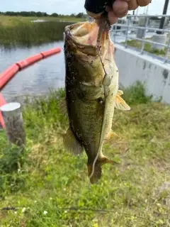
uploaded by: Joey Piercefield

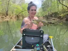
uploaded by: Joey Piercefield

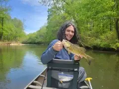
uploaded by: Joey Piercefield

uploaded by: Joey Piercefield

uploaded by: Jeanette Prince

uploaded by: Boojo

uploaded by: jennifer baldwin

uploaded by: jennifer baldwin

uploaded by: JhunB

uploaded by: arwood52130
Best Fishing Spots in the greater Fort Hamer area
Beaches and Bays are ideal places for land-based fishing. If the beach is shallow and the water is clear then twilight times are usually the best times, especially when they coincide with a major or minor fishing time. Often the points on either side of a beach are the best spots. Or if the beach is large then look for irregularities in the breaking waves, indicating sandbanks and holes. We found 17 beaches and bays in this area.
Peterson Bayou - 14km , Bolster Bayou - 16km , Clambar Bay - 16km , Terra Ceia Bay - 16km , Williams Bayou - 16km , Custer Bayou - 17km , Tillette Bayou - 17km , Champlain Bayou - 18km , Critical Bayou - 18km , Hayes Bayou - 18km , Joe Bay - 18km , Miguel Bay - 18km , Warner East Bayou - 18km , Clambar Bayou - 19km , Cockroach Bay - 19km , Mill Bayou - 19km , Warner West Bayou - 19km
Harbours and Marinas can often times be productive fishing spots for land based fishing as their sheltered environment attracts a wide variety of bait fish. Similar to river mouths, harbour entrances are also great places to fish as lots of fish will move in and out with the rising and falling tides. There are 2 main harbours in this area.
Port Manatee - 18km, Sarasota Cay Club Resort & Marina - 19km
We found a total of 77 potential fishing spots nearby Fort Hamer. Below you can find them organized on a map. Points, Headlands, Reefs, Islands, Channels, etc can all be productive fishing spots. As these are user submitted spots, there might be some errors in the exact location. You also need to cross check local fishing regulations. Some of the spots might be in or around marine reserves or other locations that cannot be fished. If you click on a location marker it will bring up some details and a quick link to google search, satellite maps and fishing times. Tip: Click/Tap on a new area to load more fishing spots.
Marsh Island - 5km , Redfish Point - 5km , Wade Canal - 6km , Branches Hammock - 7km , Frye Canal - 7km , Buffalo Canal - 8km , Ayres Point - 11km , Gilly Lakes - 12km , Green Bridge - 14km , Peterson Bayou - 14km , Sea Breeze Point - 14km , Sullivan Bridge - 14km , Bishop Harbor - 15km , Northeast Head - 15km , Point Ogden - 15km , Palmetto Point - 15km , Pearce Canal - 15km , Point Pleasant - 15km , Southeast Head - 15km , Terra Ceia River - 15km , Beville Point - 16km , Bolster Bayou - 16km , Clambar Bay - 16km , Fogarty Point - 16km , Hells Half Acre - 16km , Kitchen Key - 16km , Terra Ceia Bay - 16km , Terra Ceia Island - 16km , Williams Bayou - 16km , Bird Key - 17km , Boots Point - 17km , Cedar Hammock Drainage Canal - 17km , Custer Bayou - 17km , Harbor Key - 17km , Hooker Point - 17km , Horseshoe Key - 17km , Mariposa Key - 17km , Moses Hole - 17km , Redfish Creek - 17km , Tillette Bayou - 17km , Two Brothers Islands - 17km , Little Redfish - 17km , Champlain Bayou - 18km , Critical Bayou - 18km , Dung Islet - 18km , Fletcher Point - 18km , Gus Point - 18km , Hayes Bayou - 18km , Joe Bay - 18km , Joe Island - 18km , Miguel Bay - 18km , Piney Point - 18km , Port Manatee - 18km , Sister Keys - 18km , Snead Island - 18km , Warner East Bayou - 18km , Clambar Bayou - 19km , Cockroach Bay - 19km , Eds Key - 19km , Hallelujah Keys - 19km , Little Bird Key - 19km , McKay Point - 19km , McNeil Point - 19km , Mill Bayou - 19km , Moody Point - 19km , Paradise Island - 19km , Rattlesnake Key - 19km , Shell Key - 19km , Skeet Key - 19km , Snag Point - 19km , Warner West Bayou - 19km , Sarasota Cay Club Resort & Marina - 19km , Manbirtee Key - 19km , Beacon Key - 20km , Paradise Key - 20km , Snake Key - 20km , South Stop - 20km
Comments