


Port Mahon 🇺🇸
-
Nautical Twilight begins:04:39 amSunrise:05:47 am
-
Sunset:08:28 pmNautical Twilight ends:09:37 pm
-
Moonrise:11:44 pm
-
Moonset:11:57 am
-
Moon over:05:30 am
-
Moon under:05:50 pm
-
Visibility:65%
-
 Third Quarter Moon
-
Distance to earth:366,938 kmProximity:91 %
Moon Phases for Port Mahon
-
poor Day
-
major Time:
 04:30 am -
06:30 am
04:30 am -
06:30 am
-
minor Time:10:57 am - 12:57 pm
-
major Time:04:50 pm - 06:50 pm
-
minor Time:10:44 pm - 12:44 am
Tide Clock
Tide Graph
Times
| Tide | Time | Height |
|---|---|---|
| high | 02:10 am | 6.1 ft |
| low | 09:08 am | -0.03 ft |
| high | 02:46 pm | 5.87 ft |
| low | 09:32 pm | 0.46 ft |
| Date | Major Bite Times | Minor Bite Times | Sun | Moon | Moonphase | Tide Times |
|---|---|---|---|---|---|---|
|
Wed, 16 Jul
|
04:30 am -
06:30 am
04:50 pm -
06:50 pm
|
10:57 am -
12:57 pm
10:44 pm -
12:44 am
|
R: 05:47 am S: 08:28 pm |
R: 11:44 pm S: 11:57 am |
Third Quarter Moon |
high: 02:10 am
, 6.1 ft
, Coeff: 122
low: 09:08 am
, -0.03 ft
high: 02:46 pm
, 5.87 ft
, Coeff: 115
low: 09:32 pm
, 0.46 ft
|
|
Thu, 17 Jul
|
05:19 am -
07:19 am
05:39 pm -
07:39 pm
|
12:08 pm -
02:08 pm
11:10 pm -
01:10 am
|
R: 05:48 am S: 08:27 pm |
R: - S: 01:08 pm |
Third Quarter Moon |
high: 03:00 am
, 5.74 ft
, Coeff: 110
low: 09:56 am
, 0.03 ft
high: 03:40 pm
, 6.07 ft
, Coeff: 121
low: 10:34 pm
, 0.59 ft
|
|
Fri, 18 Jul
|
06:15 am -
08:15 am
06:31 pm -
08:31 pm
|
01:21 pm -
03:21 pm
11:10 pm -
01:10 am
|
R: 05:49 am S: 08:27 pm |
R: 12:10 am S: 02:21 pm |
Third Quarter Moon |
high: 03:55 am
, 5.31 ft
, Coeff: 96
low: 10:48 am
, 0.1 ft
high: 04:39 pm
, 6.3 ft
, Coeff: 129
low: 11:41 pm
, 0.66 ft
|
|
Sat, 19 Jul
|
07:09 am -
09:09 am
07:28 pm -
09:28 pm
|
02:38 pm -
04:38 pm
11:41 pm -
01:41 am
|
R: 05:50 am S: 08:26 pm |
R: 12:41 am S: 03:38 pm |
Third Quarter Moon |
high: 04:56 am
, 4.99 ft
, Coeff: 85
low: 11:44 am
, 0.16 ft
high: 05:41 pm
, 6.5 ft
, Coeff: 135
|
|
Sun, 20 Jul
|
08:06 am -
10:06 am
08:29 pm -
10:29 pm
|
12:18 am -
02:18 am
03:54 pm -
05:54 pm
|
R: 05:51 am S: 08:25 pm |
R: 01:18 am S: 04:54 pm |
Waning Crescent |
low: 12:50 am
, 0.62 ft
high: 06:02 am
, 4.72 ft
, Coeff: 77
low: 12:43 pm
, 0.2 ft
high: 06:45 pm
, 6.69 ft
, Coeff: 142
|
|
Mon, 21 Jul
|
09:05 am -
11:05 am
09:34 pm -
11:34 pm
|
01:04 am -
03:04 am
05:06 pm -
07:06 pm
|
R: 05:51 am S: 08:25 pm |
R: 02:04 am S: 06:06 pm |
Waning Crescent |
low: 01:58 am
, 0.52 ft
high: 07:10 am
, 4.66 ft
, Coeff: 74
low: 01:45 pm
, 0.16 ft
high: 07:49 pm
, 6.92 ft
, Coeff: 149
|
|
Tue, 22 Jul
|
10:05 am -
12:05 pm
10:39 pm -
12:39 am
|
02:02 am -
04:02 am
06:09 pm -
08:09 pm
|
R: 05:52 am S: 08:24 pm |
R: 03:02 am S: 07:09 pm |
Waning Crescent |
low: 03:02 am
, 0.36 ft
high: 08:16 am
, 4.72 ft
, Coeff: 77
low: 02:45 pm
, 0.07 ft
high: 08:49 pm
, 7.09 ft
, Coeff: 155
|


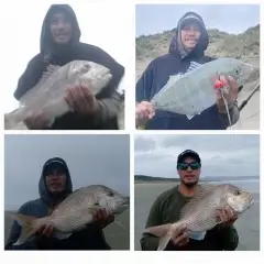
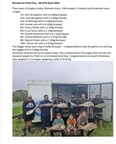
uploaded by: Hoza

uploaded by: Hoza

uploaded by: Hoza

uploaded by: Wayne Robinson_1

uploaded by: Hoza

uploaded by: Wayne Robinson_1

uploaded by: Hoza

uploaded by: JBWalker

uploaded by: primerone

uploaded by: primerone
Best Fishing Spots in the greater Port Mahon area
Beaches and Bays are ideal places for land-based fishing. If the beach is shallow and the water is clear then twilight times are usually the best times, especially when they coincide with a major or minor fishing time. Often the points on either side of a beach are the best spots. Or if the beach is large then look for irregularities in the breaking waves, indicating sandbanks and holes. We found 8 beaches and bays in this area.
Pickering Beach - 5km , Little Bombay Hook - 6km , Bay Gut - 7km , Bay Pond - 10km , Bombay Hook Island - 12km , Bombay Hook Point - 14km , Bowers Beach - 14km , Fraland Beach - 15km
Harbours and Marinas can often times be productive fishing spots for land based fishing as their sheltered environment attracts a wide variety of bait fish. Similar to river mouths, harbour entrances are also great places to fish as lots of fish will move in and out with the rising and falling tides. There are 1 main harbours in this area.
Old Marina Canal - 5km
We found a total of 98 potential fishing spots nearby Port Mahon. Below you can find them organized on a map. Points, Headlands, Reefs, Islands, Channels, etc can all be productive fishing spots. As these are user submitted spots, there might be some errors in the exact location. You also need to cross check local fishing regulations. Some of the spots might be in or around marine reserves or other locations that cannot be fished. If you click on a location marker it will bring up some details and a quick link to google search, satellite maps and fishing times. Tip: Click/Tap on a new area to load more fishing spots.
Indian Gut - 0km , Kellys Ditch - 1km , Deepwater Point - 2km , Kelly Island - 2km , Marshtown Gut - 2km , Taylors Gut - 2km , Jenkins Ditch - 3km , Old Womans Gut - 3km , Cattail Gut - 4km , Cedar Gut - 5km , Joes Hole - 5km , Kent Island - 5km , Little Creek Bridge - 5km , Old Creek - 5km , Old Marina Canal - 5km , Pickering Beach - 5km , Drum Gut - 6km , East West Canal - 6km , Flat Gut - 6km , Little Bombay Hook - 6km , North South Canal - 6km , Bay Gut - 7km , Devers Gut - 7km , Goose Point - 7km , Lewis Ditch - 7km , Marshall Island - 7km , Myrkle Gut - 7km , Boat Gut - 8km , Little Fork - 8km , Needhams Island - 8km , Ragged Island - 8km , Sand Ditch - 8km , Shearness Gut - 8km , Terrapin Gut - 8km , Georges Island - 9km , Kitts Hummock - 9km , Raymond Gut - 9km , Salt Pond Ditch - 9km , Wier Gut - 9km , Bay Pond - 10km , Hay Ditch - 10km , Log Pond - 10km , Raymond Pool Dam - 10km , Thrumcap - 10km , Alty Island - 11km , Bald Eagle Point - 11km , Bank Ditch - 11km , Cove Pond Ditch - 11km , Joseph Island - 11km , Lees Ditch - 11km , Mikes Ditch - 11km , Saint Jones Neck - 11km , Shearness Pool Dam - 11km , Silver Lake Dam - 11km , Slooch Ditch - 11km , Vansant Island - 11km , Whitehall Neck - 11km , Barkers Landing Bridge - 12km , Bombay Hook Island - 12km , Broad Gut - 12km , Collins Island - 12km , Dutch Neck Canal - 12km , Lebanon Bridge - 12km , Leipsic Bridge - 12km , Moores Lake Dam - 12km , Parson Point - 12km , Poplar Point - 12km , Raymond Neck - 12km , Bear Swamp Pool Dam - 13km , Cypress Pond - 13km , Dutch Neck - 13km , Pasture Point - 13km , Sluice Ditch - 13km , Trunk Ditch - 13km , Bombay Hook Point - 14km , Bowers Beach - 14km , Clarence Vinson Bridge - 14km , Howell Pond - 14km , Line Ditch - 14km , Long Bar Point - 14km , Fraland Beach - 15km , Fraland Cove - 15km , Matty Ditch - 15km , Quarter Gut - 15km , Snows Neck - 15km , Voshell Mill Pond Dam - 15km , Wyoming Lake Dam - 15km , Ben Davis Island (historical) - 15km , Ben Davis Point - 15km , Little Neck - 16km , Murderkill Neck - 16km , Sandy Point - 16km , Spinnell Udden (historical) - 16km , Back Creek Point - 16km , Oyster Gut - 16km , Pier Point Neck - 16km , Garrisons Lake Dam - 17km , Serverson Neck - 17km
Comments