
lake hopatcong 🇺🇸
-
Nautical Twilight begins:04:41 amSunrise:05:47 am
-
Sunset:08:03 pmNautical Twilight ends:09:10 pm
-
Moonrise:03:26 pm
-
Moonset:03:33 am
-
Moon over:09:59 pm
-
Moon under:09:29 am
-
Visibility:79%
-
 Waxing Gibbous
-
Distance to earth:399,581 kmProximity:14.4 %
Moon Phases for lake hopatcong
-
poor Day
-
minor Time:02:33 am - 04:33 am
-
major Time:08:29 am - 10:29 am
-
minor Time:02:26 pm - 04:26 pm
-
major Time:08:59 pm - 10:59 pm
Tide Clock
Tide Graph
Times
| Tide | Time | Height |
|---|---|---|
| low | 12:08 am | 1.08 ft |
| high | 05:28 am | 5.28 ft |
| low | 12:33 pm | 0.56 ft |
| high | 06:06 pm | 5.81 ft |
| Date | Major Bite Times | Minor Bite Times | Sun | Moon | Moonphase | Tide Times |
|---|---|---|---|---|---|---|
|
Wed, 07 May
|
08:29 am -
10:29 am
08:59 pm -
10:59 pm
|
02:33 am -
04:33 am
02:26 pm -
04:26 pm
|
R: 05:47 am S: 08:03 pm |
R: 03:26 pm S: 03:33 am |
Waxing Gibbous |
low: 12:08 am
, 1.08 ft
high: 05:28 am
, 5.28 ft
, Coeff: 86
low: 12:33 pm
, 0.56 ft
high: 06:06 pm
, 5.81 ft
, Coeff: 102
|
|
Thu, 08 May
|
09:09 am -
11:09 am
09:40 pm -
11:40 pm
|
02:52 am -
04:52 am
03:26 pm -
05:26 pm
|
R: 05:46 am S: 08:04 pm |
R: 04:26 pm S: 03:52 am |
Waxing Gibbous |
low: 12:57 am
, 0.92 ft
high: 06:21 am
, 5.28 ft
, Coeff: 86
low: 01:15 pm
, 0.52 ft
high: 06:52 pm
, 6.07 ft
, Coeff: 111
|
|
Fri, 09 May
|
09:48 am -
11:48 am
10:19 pm -
12:19 am
|
03:10 am -
05:10 am
04:27 pm -
06:27 pm
|
R: 05:45 am S: 08:05 pm |
R: 05:27 pm S: 04:10 am |
Waxing Gibbous |
low: 01:44 am
, 0.72 ft
high: 07:08 am
, 5.31 ft
, Coeff: 87
low: 01:55 pm
, 0.52 ft
high: 07:32 pm
, 6.3 ft
, Coeff: 118
|
|
Sat, 10 May
|
10:28 am -
12:28 pm
11:00 pm -
01:00 am
|
03:29 am -
05:29 am
05:28 pm -
07:28 pm
|
R: 05:44 am S: 08:06 pm |
R: 06:28 pm S: 04:29 am |
Full Moon |
low: 02:28 am
, 0.52 ft
high: 07:50 am
, 5.35 ft
, Coeff: 88
low: 02:34 pm
, 0.52 ft
high: 08:09 pm
, 6.46 ft
, Coeff: 123
|
|
Sun, 11 May
|
11:11 am -
01:11 pm
10:39 pm -
12:39 am
|
03:51 am -
05:51 am
06:31 pm -
08:31 pm
|
R: 05:43 am S: 08:07 pm |
R: 07:31 pm S: 04:51 am |
Full Moon |
low: 03:11 am
, 0.36 ft
high: 08:29 am
, 5.35 ft
, Coeff: 88
low: 03:13 pm
, 0.59 ft
high: 08:42 pm
, 6.53 ft
, Coeff: 125
|
|
Mon, 12 May
|
11:55 am -
01:55 pm
11:23 pm -
01:23 am
|
04:17 am -
06:17 am
07:34 pm -
09:34 pm
|
R: 05:42 am S: 08:08 pm |
R: 08:34 pm S: 05:17 am |
Full Moon |
low: 03:53 am
, 0.26 ft
high: 09:07 am
, 5.28 ft
, Coeff: 86
low: 03:51 pm
, 0.69 ft
high: 09:14 pm
, 6.5 ft
, Coeff: 124
|
|
Tue, 13 May
|
12:12 am -
02:12 am
12:42 pm -
02:42 pm
|
04:47 am -
06:47 am
08:38 pm -
10:38 pm
|
R: 05:41 am S: 08:09 pm |
R: 09:38 pm S: 05:47 am |
Full Moon |
low: 04:33 am
, 0.23 ft
high: 09:45 am
, 5.15 ft
, Coeff: 82
low: 04:27 pm
, 0.79 ft
high: 09:45 pm
, 6.4 ft
, Coeff: 121
|
")


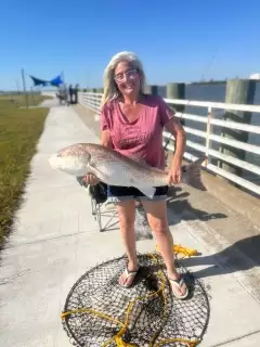
uploaded by: Joey Piercefield

uploaded by: Joey Piercefield

uploaded by: Joey Piercefield

uploaded by: Joey Piercefield

uploaded by: Jeanette Prince

uploaded by: Boojo

uploaded by: jennifer baldwin

uploaded by: jennifer baldwin

uploaded by: JhunB

uploaded by: arwood52130
Best Fishing Spots in the greater lake hopatcong area
Beaches and Bays are ideal places for land-based fishing. If the beach is shallow and the water is clear then twilight times are usually the best times, especially when they coincide with a major or minor fishing time. Often the points on either side of a beach are the best spots. Or if the beach is large then look for irregularities in the breaking waves, indicating sandbanks and holes. We found 2 beaches and bays in this area.
Byram Bay - 1km , Henderson Bay - 1km
We found a total of 100 potential fishing spots nearby lake hopatcong. Below you can find them organized on a map. Points, Headlands, Reefs, Islands, Channels, etc can all be productive fishing spots. As these are user submitted spots, there might be some errors in the exact location. You also need to cross check local fishing regulations. Some of the spots might be in or around marine reserves or other locations that cannot be fished. If you click on a location marker it will bring up some details and a quick link to google search, satellite maps and fishing times. Tip: Click/Tap on a new area to load more fishing spots.
Bishops Rock - 0km , Sun Rise Point - 1km , Raccoon Island - 1km , Pine Tree Point - 1km , Nolans Point - 1km , Point Breeze - 1km , Byram Bay - 1km , Indian Harbor - 1km , Indian Island - 1km , Henderson Bay - 1km , Halsey Island - 1km , Elba Point - 1km , Cow Tongue Point - 1km , Davis Cove - 1km , Van Every Cove - 2km , Sister Islands - 2km , Sharps Point - 2km , River Styx - 2km , Bear Pond - 2km , Pickerel Point - 2km , Byram Cove - 2km , Chestnut Point - 2km , Henderson Cove - 2km , Great Cove - 2km , County Island - 2km , Bedbug Island - 3km , Bertrand Island - 3km , Liffy Island - 3km , Ingram Cove - 3km , Lake Shawnee Dam - 4km , Lake Hopatcong Dam - 4km , King Cove - 4km , Wolf Lake - 5km , Lake Winona - 5km , Tomahawk Lake Dam - 5km , Seneca Lake - 5km , Lake Louise - 5km , Lake Lackawanna Dam - 5km , Kofferls Pond Dam - 5km , Floating Island - 5km , Dunlap Pond - 5km , Laidlaws Pond - 6km , Stag Pond - 6km , Lake Rogerene - 6km , Fowlers Pond - 6km , Hughs Pond - 6km , Picatinny Lake Dam - 7km , Duck Pond - 7km , Johnson Lake Dam - 7km , Mountain Pond - 7km , Mountain Lake - 7km , Blue Heron Lake Dam - 7km , Beisers Pond - 8km , Cub Lake - 8km , Cranberry Lake Dam - 8km , Lake Denmark - 8km , Panther Lake - 8km , Jefferson Lake Dam - 8km , Mount Hope Pond Dam - 8km , Lake Musconetcong Dam - 8km , Lake Saginaw Dam - 8km , Forest Lake Dam - 8km , Hemlock Lake Dam - 8km , Ledgewood Pond - 8km , Longwood Lake Dam - 8km , Lake Saginaw - 8km , Marine Lake - 8km , Lake Denmark Dam - 9km , Lake Lenape Dam - 9km , Emilio Perona Dam - 9km , Lake Mohawk Dam - 9km , Strawberry Point - 9km , Upper Mohawk Lake Dam - 9km , Bowlby Pond - 9km , Arapaho Lake - 9km , Upper Lake Mohawk - 9km , Sunset Lake Dam - 9km , Brownwood Pond - 10km , Buckmire Pond - 10km , Straders Pond - 10km , Clark Pond - 10km , Black River Pond - 10km , Mount Hope Lake Dam - 10km , Conkling Pond - 10km , Morris Lake Dam - 10km , Triple Lakes - 10km , Fox Hollow Dam - 10km , New Wawayanda Lake Dam - 10km , Gardners Pond Dam - 10km , Horseshoe Lake - 11km , Rock Ridge Lake Dam - 11km , Rock Island Lake Dam - 11km , Lake Iliff - 11km , White Meadow Lake Dam - 11km , Howells Pond - 11km , Lake Ames - 11km , Turtle Pond - 11km , Whites Pond - 11km , Twin Lakes - 11km , Sparta Lake Dam - 12km
Comments