

Gorham 🇺🇸
-
Nautical Twilight begins:04:39 amSunrise:05:47 am
-
Sunset:07:45 pmNautical Twilight ends:08:53 pm
-
Moonrise:11:22 pm
-
Moonset:02:40 pm
-
Moon over:06:41 am
-
Moon under:07:01 pm
-
Visibility:45%
-
 Third Quarter Moon
-
Distance to earth:363,881 kmProximity:98.2 %
Moon Phases for Gorham
-
average Day
-
major Time:
 05:41 am -
07:41 am
05:41 am -
07:41 am
-
minor Time:01:40 pm - 03:40 pm
-
major Time:
06:01 pm -
08:01 pm
-
minor Time:10:22 pm - 12:22 am
Tide Clock
Tide Graph
Times
| Tide | Time | Height |
|---|---|---|
| high | 05:02 am | 9.06 ft |
| low | 11:03 am | 0.49 ft |
| high | 05:24 pm | 10.2 ft |
| low | 11:53 pm | 0.13 ft |
| Date | Major Bite Times | Minor Bite Times | Sun | Moon | Moonphase | Tide Times |
|---|---|---|---|---|---|---|
|
Sat, 16 Aug
|
05:41 am -
07:41 am
06:01 pm -
08:01 pm
|
01:40 pm -
03:40 pm
10:22 pm -
12:22 am
|
R: 05:47 am S: 07:45 pm |
R: 11:22 pm S: 02:40 pm |
Third Quarter Moon |
high: 05:02 am
, 9.06 ft
, Coeff: 105
low: 11:03 am
, 0.49 ft
high: 05:24 pm
, 10.2 ft
, Coeff: 129
low: 11:53 pm
, 0.13 ft
|
|
Sun, 17 Aug
|
06:44 am -
08:44 am
07:04 pm -
09:04 pm
|
02:56 pm -
04:56 pm
11:12 pm -
01:12 am
|
R: 05:48 am S: 07:44 pm |
R: - S: 03:56 pm |
Third Quarter Moon |
high: 06:07 am
, 8.63 ft
, Coeff: 97
low: 12:04 pm
, 0.89 ft
high: 06:27 pm
, 10.07 ft
, Coeff: 126
|
|
Mon, 18 Aug
|
07:36 am -
09:36 am
08:07 pm -
10:07 pm
|
04:01 pm -
06:01 pm
11:12 pm -
01:12 am
|
R: 05:49 am S: 07:42 pm |
R: 12:12 am S: 05:01 pm |
Waning Crescent |
low: 01:02 am
, 0.23 ft
high: 07:16 am
, 8.4 ft
, Coeff: 92
low: 01:11 pm
, 1.12 ft
high: 07:34 pm
, 10.04 ft
, Coeff: 125
|
|
Tue, 19 Aug
|
08:34 am -
10:34 am
09:10 pm -
11:10 pm
|
12:14 am -
02:14 am
04:54 pm -
06:54 pm
|
R: 05:50 am S: 07:41 pm |
R: 01:14 am S: 05:54 pm |
Waning Crescent |
low: 02:11 am
, 0.2 ft
high: 08:26 am
, 8.4 ft
, Coeff: 92
low: 02:19 pm
, 1.12 ft
high: 08:41 pm
, 10.1 ft
, Coeff: 127
|
|
Wed, 20 Aug
|
09:30 am -
11:30 am
10:08 pm -
12:08 am
|
01:26 am -
03:26 am
05:34 pm -
07:34 pm
|
R: 05:51 am S: 07:39 pm |
R: 02:26 am S: 06:34 pm |
Waning Crescent |
low: 03:16 am
, 0.03 ft
high: 09:31 am
, 8.6 ft
, Coeff: 96
low: 03:23 pm
, 0.92 ft
high: 09:43 pm
, 10.24 ft
, Coeff: 129
|
|
Thu, 21 Aug
|
10:24 am -
12:24 pm
11:01 pm -
01:01 am
|
02:42 am -
04:42 am
06:06 pm -
08:06 pm
|
R: 05:52 am S: 07:37 pm |
R: 03:42 am S: 07:06 pm |
New Moon |
low: 04:13 am
, -0.16 ft
high: 10:28 am
, 8.89 ft
, Coeff: 102
low: 04:21 pm
, 0.66 ft
high: 10:39 pm
, 10.37 ft
, Coeff: 132
|
|
Fri, 22 Aug
|
11:13 am -
01:13 pm
10:37 pm -
12:37 am
|
03:56 am -
05:56 am
06:31 pm -
08:31 pm
|
R: 05:53 am S: 07:36 pm |
R: 04:56 am S: 07:31 pm |
New Moon |
low: 05:05 am
, -0.33 ft
high: 11:18 am
, 9.15 ft
, Coeff: 107
low: 05:13 pm
, 0.43 ft
high: 11:30 pm
, 10.43 ft
, Coeff: 133
|


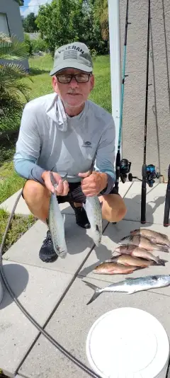
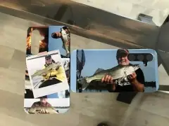
uploaded by: Munta

uploaded by: todd douglas

uploaded by: primerone
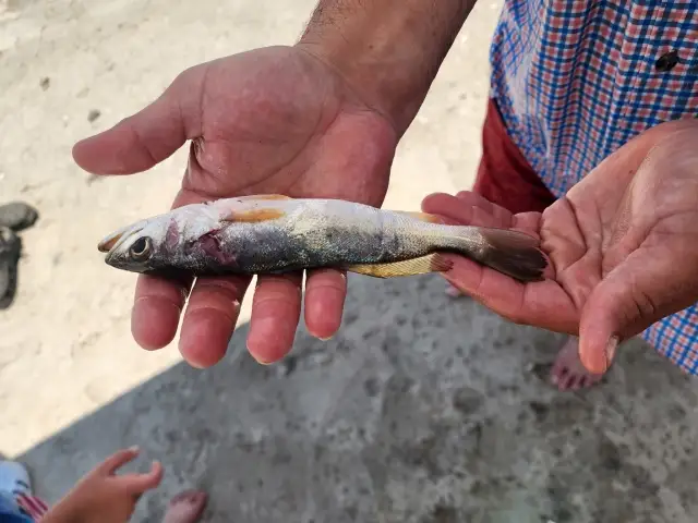
uploaded by: Ryan Frazier

uploaded by: Hoza

uploaded by: Alan Baker

uploaded by: Granpa C

uploaded by: Asaad S Shalbi

uploaded by: Hoza

uploaded by: Hoza
Gorem,Gorkham,Gorkhehm,Gorum,Горем,Горхам,Горхэм,Горъм
Best Fishing Spots in the greater Gorham area
Wharf's or Jetties are good places to wet a line and meet other fishermen. They often produce a fresh feed of fish and are also great to catch bait fish. As they are often well lit, they also provide a good opportunity for night fishing. There are 8 wharf(s) in this area.
Browns Wharf - 16km , Chandlers Wharf - 16km , Cumberland Wharf - 16km , Custom House Wharf - 16km , Hobsons Wharf - 16km , Long Wharf - 16km , Union Wharf - 16km , Wrights Wharf - 16km
Beaches and Bays are ideal places for land-based fishing. If the beach is shallow and the water is clear then twilight times are usually the best times, especially when they coincide with a major or minor fishing time. Often the points on either side of a beach are the best spots. Or if the beach is large then look for irregularities in the breaking waves, indicating sandbanks and holes. We found 8 beaches and bays in this area.
Lower Bay - 12km , Back Shore - 18km , Pine Point Beach - 18km , Surfside Beach - 18km , Camp Cove - 19km , Old Orchard Beach - 19km , Scarborough Beach - 19km , Western Beach - 19km
Harbours and Marinas can often times be productive fishing spots for land based fishing as their sheltered environment attracts a wide variety of bait fish. Similar to river mouths, harbour entrances are also great places to fish as lots of fish will move in and out with the rising and falling tides. There are 2 main harbours in this area.
Portland Bridge - 15km, Old Port - 16km
We found a total of 98 potential fishing spots nearby Gorham. Below you can find them organized on a map. Points, Headlands, Reefs, Islands, Channels, etc can all be productive fishing spots. As these are user submitted spots, there might be some errors in the exact location. You also need to cross check local fishing regulations. Some of the spots might be in or around marine reserves or other locations that cannot be fished. If you click on a location marker it will bring up some details and a quick link to google search, satellite maps and fishing times. Tip: Click/Tap on a new area to load more fishing spots.
Beaver Pond - 6km , Little Falls Dam - 6km , Mallison Falls Dam - 6km , Saccarappa Dam - 6km , Cumberland Dam - 7km , Duck Pond - 7km , Haskell Pond - 7km , Gambo Falls Dam - 8km , Loveitt Bridge - 9km , Babbs Bridge - 10km , Highland Lake Dam - 10km , Riverton Bridge - 10km , Rye Pond (historical) - 10km , Bar Mills Dam - 11km , Bonny Eagle Pond - 11km , Capisic Pond - 11km , Dundee Pond Dam - 11km , Otter Ponds - 11km , Snake Pond - 11km , Stroudwater Dam - 11km , Clark Pond Dam - 12km , Highland Lake - 12km , Lower Bay - 12km , Indian Island - 13km , Thompson Point - 13km , West Buxton Dam - 13km , Back Cove - 14km , Bonney Eagle Dam - 14km , Foxwells Bridge Brook Dam - 14km , Great Falls Bridge - 14km , Mill Brook Dam - 14km , North Gorham Dam - 14km , Vaughans Bridge (historical) - 14km , Veterans Memorial Bridge - 14km , Big Island - 15km , Eel Weir Dam - 15km , Gillman Island - 15km , Middle Island - 15km , Portland Bridge - 15km , Skelton Dam - 15km , Tukey Bridge - 15km , Turner Island - 15km , Winnocks Neck - 15km , Blueberry Island - 16km , Browns Wharf - 16km , Chandlers Wharf - 16km , Cumberland Wharf - 16km , Custom House Wharf - 16km , Eel Weir Bridge - 16km , Eel Weir Canal - 16km , Hobsons Wharf - 16km , Lily Pond - 16km , Little Duck Pond - 16km , Long Wharf - 16km , Martin Point - 16km , Martin Point Bridge - 16km , Nonesuch Point - 16km , Nonesuch Cove - 16km , Old Port - 16km , Plummer Island - 16km , Rich Mill Pond Dam - 16km , Treasure Island - 16km , Union Wharf - 16km , Wales Pond - 16km , Watchic Pond Dam - 16km , Wrights Wharf - 16km , Collins Pond - 17km , Cooks Brook Dam - 17km , Lindsay Island - 17km , Little Watchic Pond - 17km , Sebago Lake Dam - 17km , Back Shore - 18km , Ferry Rock - 18km , Forest Lake - 18km , Little Sebago Lake Dam - 18km , Massacre Pond - 18km , Mill Pond Dam - 18km , Milliken Pond - 18km , Pine Point Beach - 18km , Prouts Neck - 18km , Squaw Island - 18km , Surfside Beach - 18km , Tarkill Pond - 18km , Brown Cove - 19km , Camp Cove - 19km , Chaffin Pond - 19km , Clubhouse Cove - 19km , Frye Island - 19km , Mud Ponds - 19km , Old Orchard Beach - 19km , Papoose Island - 19km , Scarborough Beach - 19km , Shelldrake Point - 19km , Shelldrake Cove - 19km , Western Beach - 19km , Western Cove - 19km , Whites Bridge - 19km , Whites Point - 19km
Comments