

Marshallton 🇺🇸
-
Nautical Twilight begins:05:14 amSunrise:06:17 am
-
Sunset:08:03 pmNautical Twilight ends:09:06 pm
-
Moonrise:-
-
Moonset:04:08 pm
-
Moon over:08:09 am
-
Moon under:08:29 pm
-
Visibility:34%
-
 Third Quarter Moon
-
Distance to earth:365,588 kmProximity:94.2 %
Moon Phases for Marshallton
-
average Day
-
major Time:07:09 am - 09:09 am
-
minor Time:03:08 pm - 05:08 pm
-
major Time:
 07:29 pm -
09:29 pm
07:29 pm -
09:29 pm
-
minor Time:11:51 pm - 01:51 am
| Date | Major Bite Times | Minor Bite Times | Sun | Moon | Moonphase |
|---|---|---|---|---|---|
|
Sun, 17 Aug
|
07:09 am -
09:09 am
07:29 pm -
09:29 pm
|
03:08 pm -
05:08 pm
11:51 pm -
01:51 am
|
R: 06:17 am S: 08:03 pm |
R: - S: 04:08 pm |
Third Quarter Moon |
|
Mon, 18 Aug
|
08:02 am -
10:02 am
08:33 pm -
10:33 pm
|
04:13 pm -
06:13 pm
11:51 pm -
01:51 am
|
R: 06:18 am S: 08:01 pm |
R: 12:51 am S: 05:13 pm |
Waning Crescent |
|
Tue, 19 Aug
|
08:59 am -
10:59 am
09:35 pm -
11:35 pm
|
12:53 am -
02:53 am
05:06 pm -
07:06 pm
|
R: 06:19 am S: 08:00 pm |
R: 01:53 am S: 06:06 pm |
Waning Crescent |
|
Wed, 20 Aug
|
09:56 am -
11:56 am
10:33 pm -
12:33 am
|
02:04 am -
04:04 am
05:49 pm -
07:49 pm
|
R: 06:20 am S: 07:58 pm |
R: 03:04 am S: 06:49 pm |
Waning Crescent |
|
Thu, 21 Aug
|
10:50 am -
12:50 pm
11:27 pm -
01:27 am
|
03:17 am -
05:17 am
06:23 pm -
08:23 pm
|
R: 06:21 am S: 07:57 pm |
R: 04:17 am S: 07:23 pm |
New Moon |
|
Fri, 22 Aug
|
11:40 am -
01:40 pm
11:05 pm -
01:05 am
|
04:30 am -
06:30 am
06:50 pm -
08:50 pm
|
R: 06:22 am S: 07:55 pm |
R: 05:30 am S: 07:50 pm |
New Moon |
|
Sat, 23 Aug
|
12:25 pm -
02:25 pm
11:52 pm -
01:52 am
|
05:39 am -
07:39 am
07:12 pm -
09:12 pm
|
R: 06:23 am S: 07:54 pm |
R: 06:39 am S: 08:12 pm |
New Moon |


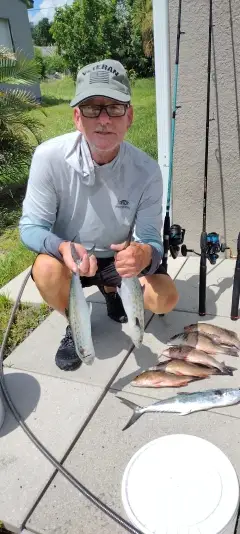
uploaded by: Munta

uploaded by: todd douglas

uploaded by: primerone
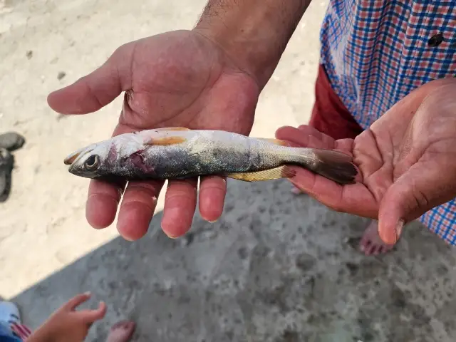
uploaded by: Ryan Frazier

uploaded by: Hoza

uploaded by: Alan Baker

uploaded by: Granpa C

uploaded by: Asaad S Shalbi

uploaded by: Hoza

uploaded by: Hoza
Best Fishing Spots in the greater Marshallton area
We found a total of 20 potential fishing spots nearby Marshallton. Below you can find them organized on a map. Points, Headlands, Reefs, Islands, Channels, etc can all be productive fishing spots. As these are user submitted spots, there might be some errors in the exact location. You also need to cross check local fishing regulations. Some of the spots might be in or around marine reserves or other locations that cannot be fished. If you click on a location marker it will bring up some details and a quick link to google search, satellite maps and fishing times. Tip: Click/Tap on a new area to load more fishing spots.
Trout Run Dam Number Four - 3km , Bear Gap Number Two Dam - 6km , Locust Summit Fines Plant Dam - 11km , Storage Reservoir Number Two Dam - 11km , Reeder Covered Bridge (historical) - 11km , Bear Gap Number Six Dam - 11km , Lawrence L Knoebel Covered Bridge - 11km , Dam Number Five - 11km , Rohrbach Covered Bridge (historical) - 13km , Riegel Covered Bridge - 14km , Trevorton Plant Number One Dam - 14km , Brush Valley Dam - 16km , Beury Lake - 16km , Reeds Island - 17km , Sunshine Coal Company Number Sixteen Dam - 17km , Vastines Island - 17km , Dell Lake - 18km , Menches Island - 18km , Clarks Island - 19km , Fish Pond Dam - 20km
Comments