


Cherryfield 🇺🇸
-
Nautical Twilight begins:05:11 amSunrise:06:13 am
-
Sunset:06:38 pmNautical Twilight ends:07:40 pm
-
Moonrise:02:30 am
-
Moonset:05:27 pm
-
Moon over:09:58 am
-
Moon under:10:35 pm
-
Visibility:10%
-
 Waning Crescent
-
Distance to earth:383,277 kmProximity:52.6 %
Moon Phases for Cherryfield
-
average Day
-
minor Time:01:30 am - 03:30 am
-
major Time:08:58 am - 10:58 am
-
minor Time:04:27 pm - 06:27 pm
-
major Time:09:35 pm - 11:35 pm
Tide Clock
Tide Graph
Times
| Tide | Time | Height |
|---|---|---|
| low | 03:07 am | 0.3 ft |
| high | 09:03 am | 10.79 ft |
| low | 03:20 pm | 0.98 ft |
| high | 09:19 pm | 12.14 ft |
| Date | Major Bite Times | Minor Bite Times | Sun | Moon | Moonphase | Tide Times |
|---|---|---|---|---|---|---|
|
Thu, 18 Sep
|
08:58 am -
10:58 am
09:35 pm -
11:35 pm
|
01:30 am -
03:30 am
04:27 pm -
06:27 pm
|
R: 06:13 am S: 06:38 pm |
R: 02:30 am S: 05:27 pm |
Waning Crescent |
low: 03:07 am
, 0.3 ft
high: 09:03 am
, 10.79 ft
, Coeff: 93
low: 03:20 pm
, 0.98 ft
high: 09:19 pm
, 12.14 ft
, Coeff: 115
|
|
Fri, 19 Sep
|
09:45 am -
11:45 am
10:20 pm -
12:20 am
|
02:43 am -
04:43 am
04:48 pm -
06:48 pm
|
R: 06:14 am S: 06:36 pm |
R: 03:43 am S: 05:48 pm |
Waning Crescent |
low: 04:01 am
, 0.13 ft
high: 09:56 am
, 11.19 ft
, Coeff: 99
low: 04:14 pm
, 0.66 ft
high: 10:11 pm
, 12.27 ft
, Coeff: 117
|
|
Sat, 20 Sep
|
10:28 am -
12:28 pm
11:02 pm -
01:02 am
|
03:52 am -
05:52 am
05:05 pm -
07:05 pm
|
R: 06:16 am S: 06:34 pm |
R: 04:52 am S: 06:05 pm |
New Moon |
low: 04:48 am
, 0.07 ft
high: 10:41 am
, 11.52 ft
, Coeff: 105
low: 05:03 pm
, 0.36 ft
high: 10:58 pm
, 12.27 ft
, Coeff: 117
|
|
Sun, 21 Sep
|
11:11 am -
01:11 pm
10:38 pm -
12:38 am
|
05:00 am -
07:00 am
05:22 pm -
07:22 pm
|
R: 06:17 am S: 06:32 pm |
R: 06:00 am S: 06:22 pm |
New Moon |
low: 05:31 am
, 0.07 ft
high: 11:22 am
, 11.75 ft
, Coeff: 108
low: 05:46 pm
, 0.2 ft
high: 11:40 pm
, 12.11 ft
, Coeff: 114
|
|
Mon, 22 Sep
|
11:52 am -
01:52 pm
11:19 pm -
01:19 am
|
06:06 am -
08:06 am
05:38 pm -
07:38 pm
|
R: 06:18 am S: 06:31 pm |
R: 07:06 am S: 06:38 pm |
New Moon |
low: 06:08 am
, 0.23 ft
high: 11:59 am
, 11.84 ft
, Coeff: 110
low: 06:27 pm
, 0.16 ft
|
|
Tue, 23 Sep
|
12:00 am -
02:00 am
12:33 pm -
02:33 pm
|
07:11 am -
09:11 am
05:56 pm -
07:56 pm
|
R: 06:19 am S: 06:29 pm |
R: 08:11 am S: 06:56 pm |
New Moon |
high: 12:19 am
, 11.84 ft
, Coeff: 110
low: 06:44 am
, 0.49 ft
high: 12:33 pm
, 11.84 ft
, Coeff: 110
low: 07:05 pm
, 0.23 ft
|
|
Wed, 24 Sep
|
12:43 am -
02:43 am
01:16 pm -
03:16 pm
|
08:17 am -
10:17 am
06:15 pm -
08:15 pm
|
R: 06:20 am S: 06:27 pm |
R: 09:17 am S: 07:15 pm |
Waxing Crescent |
high: 12:56 am
, 11.45 ft
, Coeff: 104
low: 07:18 am
, 0.79 ft
high: 01:07 pm
, 11.75 ft
, Coeff: 108
low: 07:42 pm
, 0.43 ft
|


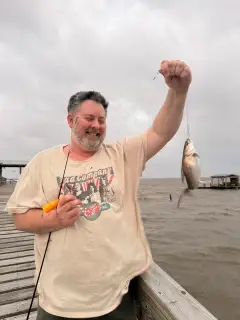
uploaded by: Salim Jamia

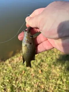
uploaded by: rich77

uploaded by: rich77

uploaded by: rich77

uploaded by: Rex_Ursus

uploaded by: bandedwd

uploaded by: Trey Cowan

uploaded by: Trey Cowan

uploaded by: Trey Cowan

uploaded by: Trey Cowan
Best Fishing Spots in the greater Cherryfield area
Beaches and Bays are ideal places for land-based fishing. If the beach is shallow and the water is clear then twilight times are usually the best times, especially when they coincide with a major or minor fishing time. Often the points on either side of a beach are the best spots. Or if the beach is large then look for irregularities in the breaking waves, indicating sandbanks and holes. We found 6 beaches and bays in this area.
Back Bay - 9km , Flat Bay - 9km , Jordan Beach - 10km , Harrington Bay - 12km , Pinkham Bay - 13km , Joy Bay - 14km
We found a total of 99 potential fishing spots nearby Cherryfield. Below you can find them organized on a map. Points, Headlands, Reefs, Islands, Channels, etc can all be productive fishing spots. As these are user submitted spots, there might be some errors in the exact location. You also need to cross check local fishing regulations. Some of the spots might be in or around marine reserves or other locations that cannot be fished. If you click on a location marker it will bring up some details and a quick link to google search, satellite maps and fishing times. Tip: Click/Tap on a new area to load more fishing spots.
Cherryfield Dam - 1km , The Crotch - 2km , Mill Pond - 7km , Round Pond - 7km , Downing Pond - 7km , Long Pond - 8km , Back Bay - 9km , Flat Bay - 9km , Fish Point - 9km , Oak Point - 9km , Cranberry Island (historical) - 9km , East Steuben Dam - 10km , Schoodic Lake - 10km , Lily Cove - 10km , Lenroy Island - 10km , Sand Cove - 10km , Jordan Beach - 10km , Spring River Lake - 10km , Myers Ponds - 10km , Strout Point - 10km , The Folly - 10km , Fickett Point - 10km , Timmy Point - 10km , Partiridge Island - 10km , Partridge Island - 10km , Blasket Point - 10km , Pinkham Island - 10km , Long Point - 11km , Plummer Point - 11km , Chamberly Island - 11km , Lords Island - 11km , Cole Point - 11km , Cow Island - 11km , Anderson Pond - 11km , Crow Island - 11km , Sandy Cove - 11km , Ray Point - 11km , Trout Cove - 11km , Lilly Pond - 11km , Five Island - 11km , Five Islands Cove - 11km , Nash Point - 11km , Horseshoe Pond - 11km , Pineo Point - 11km , Hornet Island - 11km , Mouse Island - 11km , Coffins Point - 12km , Turner Point - 12km , Tunk Lake - 12km , Ripley Cove - 12km , West Carrying Place Cove - 12km , Timber Cove - 12km , East Pike Brook Pond - 12km , Ripley Islands - 12km , Pineo Pond - 12km , Tilden Pond - 12km , Foster Island - 12km , Mitchell Point - 12km , Spectacle Ponds - 12km , Steuben Harbor - 12km , Hardwood Point - 12km , Harrington Bay - 12km , Carrying Place Cove - 13km , Val Point - 13km , Upper Wass Cove - 13km , Parrit Point - 13km , Parrit Cove - 13km , Little Long Pond - 13km , Shag Island - 13km , Baker Cove - 13km , Baker Point - 13km , Salmon Pond - 13km , Joy Cove - 13km , Pinkham Bay - 13km , Smith Cove - 13km , Pine Island - 13km , Big Muckleberry Pond - 13km , Myrick Lake - 13km , Stevens Point - 13km , Hog Island - 13km , Mud Pond - 13km , Barbless Pond Dam - 13km , Fort Island - 14km , Look Point - 14km , Lower Wass Cove - 14km , Little Fort Island - 14km , Joy Bay - 14km , Wilmot Cove - 14km , Coffin Brook Pond - 14km , Muckleberry Pond - 14km , Otter Island - 14km , West Branch Pleasant River Dam - 14km , Deer Island - 14km , Ramsdell Cove - 14km , Bray Point - 14km , Wass Point - 14km , Wall Point - 14km , Channel Rock - 14km , Bungy Rock - 14km
Comments