
La Mesa 🇺🇸
-
Nautical Twilight begins:05:39 amSunrise:06:31 am
-
Sunset:06:55 pmNautical Twilight ends:07:48 pm
-
Moonrise:12:06 am
-
Moonset:03:22 pm
-
Moon over:07:44 am
-
Moon under:08:17 pm
-
Visibility:35%
-
 Third Quarter Moon
-
Distance to earth:370,600 kmProximity:82.4 %
Moon Phases for La Mesa
-
average Day
-
major Time:06:44 am - 08:44 am
-
minor Time:02:22 pm - 04:22 pm
-
major Time:07:17 pm - 09:17 pm
-
minor Time:11:06 pm - 01:06 am
Tide Clock
Tide Graph
Times
| Tide | Time | Height |
|---|---|---|
| high | 07:05 am | 3.87 ft |
| low | 10:47 am | 3.35 ft |
| high | 05:03 pm | 5.77 ft |
| Date | Major Bite Times | Minor Bite Times | Sun | Moon | Moonphase | Tide Times |
|---|---|---|---|---|---|---|
|
Mon, 15 Sep
|
06:44 am -
08:44 am
07:17 pm -
09:17 pm
|
02:22 pm -
04:22 pm
11:06 pm -
01:06 am
|
R: 06:31 am S: 06:55 pm |
R: 12:06 am S: 03:22 pm |
Third Quarter Moon |
high: 07:05 am
, 3.87 ft
, Coeff: 51
low: 10:47 am
, 3.35 ft
high: 05:03 pm
, 5.77 ft
, Coeff: 116
|
|
Tue, 16 Sep
|
07:41 am -
09:41 am
08:15 pm -
10:15 pm
|
12:12 am -
02:12 am
03:10 pm -
05:10 pm
|
R: 06:32 am S: 06:54 pm |
R: 01:12 am S: 04:10 pm |
Waning Crescent |
low: 12:46 am
, -0.26 ft
high: 07:44 am
, 4.36 ft
, Coeff: 68
low: 12:21 pm
, 2.92 ft
high: 06:20 pm
, 6.04 ft
, Coeff: 124
|
|
Wed, 17 Sep
|
08:34 am -
10:34 am
09:08 pm -
11:08 pm
|
01:19 am -
03:19 am
03:50 pm -
05:50 pm
|
R: 06:32 am S: 06:53 pm |
R: 02:19 am S: 04:50 pm |
Waning Crescent |
low: 01:35 am
, -0.52 ft
high: 08:15 am
, 4.76 ft
, Coeff: 81
low: 01:21 pm
, 2.33 ft
high: 07:17 pm
, 6.27 ft
, Coeff: 132
|
|
Thu, 18 Sep
|
09:24 am -
11:24 am
09:55 pm -
11:55 pm
|
02:26 am -
04:26 am
04:23 pm -
06:23 pm
|
R: 06:33 am S: 06:51 pm |
R: 03:26 am S: 05:23 pm |
Waning Crescent |
low: 02:14 am
, -0.62 ft
high: 08:43 am
, 5.12 ft
, Coeff: 93
low: 02:06 pm
, 1.77 ft
high: 08:04 pm
, 6.36 ft
, Coeff: 136
|
|
Fri, 19 Sep
|
10:10 am -
12:10 pm
10:41 pm -
12:41 am
|
03:28 am -
05:28 am
04:52 pm -
06:52 pm
|
R: 06:33 am S: 06:50 pm |
R: 04:28 am S: 05:52 pm |
Waning Crescent |
low: 02:47 am
, -0.56 ft
high: 09:08 am
, 5.41 ft
, Coeff: 103
low: 02:46 pm
, 1.31 ft
high: 08:45 pm
, 6.3 ft
, Coeff: 133
|
|
Sat, 20 Sep
|
10:53 am -
12:53 pm
11:22 pm -
01:22 am
|
04:29 am -
06:29 am
05:18 pm -
07:18 pm
|
R: 06:34 am S: 06:48 pm |
R: 05:29 am S: 06:18 pm |
New Moon |
low: 03:15 am
, -0.33 ft
high: 09:32 am
, 5.68 ft
, Coeff: 112
low: 03:21 pm
, 0.95 ft
high: 09:21 pm
, 6.07 ft
, Coeff: 126
|
|
Sun, 21 Sep
|
11:34 am -
01:34 pm
11:05 pm -
01:05 am
|
05:26 am -
07:26 am
05:43 pm -
07:43 pm
|
R: 06:35 am S: 06:47 pm |
R: 06:26 am S: 06:43 pm |
New Moon |
low: 03:41 am
, -0 ft
high: 09:54 am
, 5.84 ft
, Coeff: 118
low: 03:55 pm
, 0.69 ft
high: 09:56 pm
, 5.74 ft
, Coeff: 114
|


uploaded by: Heathen Monk

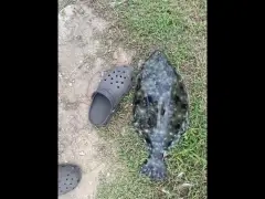
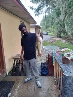
uploaded by: Flounder pounder

uploaded by: Stephen Spencer

uploaded by: Jon “Kuse”

uploaded by: Elzen Harris

uploaded by: RAMason69

uploaded by: Steven Butcheck

uploaded by: Joey Piercefield

uploaded by: Hoza

uploaded by: John Matthews
Best Fishing Spots in the greater La Mesa area
Wharf's or Jetties are good places to wet a line and meet other fishermen. They often produce a fresh feed of fish and are also great to catch bait fish. As they are often well lit, they also provide a good opportunity for night fishing. There are 1 wharf(s) in this area.
Culvarwells Wharf (historical) - 15km
Beaches and Bays are ideal places for land-based fishing. If the beach is shallow and the water is clear then twilight times are usually the best times, especially when they coincide with a major or minor fishing time. Often the points on either side of a beach are the best spots. Or if the beach is large then look for irregularities in the breaking waves, indicating sandbanks and holes. We found 10 beaches and bays in this area.
San Diego-Coronado Bay Bridge - 15km , South San Diego Bay - 16km , North San Diego Bay - 17km , San Diego Bay - 17km , Coronado Shores Beach - 17km , Glorietta Bay Marina - 17km , Glorietta Bay - 17km , Central Beach - 18km , North Beach - 18km , Coronado City Beach - 18km
Harbours and Marinas can often times be productive fishing spots for land based fishing as their sheltered environment attracts a wide variety of bait fish. Similar to river mouths, harbour entrances are also great places to fish as lots of fish will move in and out with the rising and falling tides. There are 6 main harbours in this area.
Marriott San Diego Hotel and Marina - 15km, East Basin - 16km, Glorietta Bay Marina - 17km, Sheraton San Diego Hotel and Marina - 17km, West Basin - 18km, Chula Vista Harbor - 18km
We found a total of 60 potential fishing spots nearby La Mesa. Below you can find them organized on a map. Points, Headlands, Reefs, Islands, Channels, etc can all be productive fishing spots. As these are user submitted spots, there might be some errors in the exact location. You also need to cross check local fishing regulations. Some of the spots might be in or around marine reserves or other locations that cannot be fished. If you click on a location marker it will bring up some details and a quick link to google search, satellite maps and fishing times. Tip: Click/Tap on a new area to load more fishing spots.
Earl Thomas Reservoir 8-015 Dam - 2km , Murray 8-012 Dam - 3km , Alvarado Regulating 8-013 Dam - 3km , Chollas 8-002 Dam - 5km , Old Mission Dam - 8km , Neal Cove - 8km , Gum Tree Cove - 8km , Willow Tree Dam - 9km , Sweetwater Main 2020 Dam - 9km , Steele Canyon Bridge - 9km , Cottonwood 861 Dam - 10km , Cabrillo Bridge - 13km , Seventh Street Channel - 13km , Indian Point - 14km , Lindo Lake - 14km , Culvarwells Wharf (historical) - 15km , Marriott San Diego Hotel and Marina - 15km , Dead Mans Point - 15km , San Diego-Coronado Bay Bridge - 15km , East Basin - 16km , Upper Otay 8-008 Dam - 16km , Chet Harritt Dam - 16km , Sweetwater Channel - 16km , South San Diego Bay - 16km , Chet Harritt 56-009 Dam - 16km , North San Diego Bay - 17km , Peninsula Point (historical) - 17km , San Diego Bay - 17km , Silver Strand - 17km , Coronado Shores Beach - 17km , Gunpowder Point - 17km , Glorietta Bay Marina - 17km , Glorietta Bay - 17km , Sheraton San Diego Hotel and Marina - 17km , Spanish Bight (historical) - 18km , Central Beach - 18km , West Basin - 18km , Point De Anza - 18km , North Beach - 18km , Crown Island - 18km , De Anza Cove - 18km , Crown Cove - 18km , Enchanted Cove - 18km , Enchanted Isle - 18km , Fiesta Island - 18km , Harbor Island - 18km , Leisure Lagoon - 18km , Coronado City Beach - 18km , Point Lowell - 18km , Miramar 8-011 Dam - 18km , Chula Vista Harbor - 18km , North Island - 18km , Hidden Anchorage - 19km , San Vicente 8-009 Dam - 19km , Coronado Wye - 19km , Coronado Cays - 19km , Rose Inlet - 19km , Buschalaugh Cove - 19km , Blossom Valley Reservoir 1060 Dam - 19km , Savage Dam - 20km
Comments