


Vergennes 🇺🇸
-
Nautical Twilight begins:05:33 amSunrise:06:35 am
-
Sunset:06:59 pmNautical Twilight ends:08:01 pm
-
Moonrise:02:53 am
-
Moonset:05:48 pm
-
Moon over:10:20 am
-
Moon under:10:57 pm
-
Visibility:10%
-
 Waning Crescent
-
Distance to earth:383,277 kmProximity:52.6 %
Moon Phases for Vergennes
-
average Day
-
minor Time:01:53 am - 03:53 am
-
major Time:09:20 am - 11:20 am
-
minor Time:04:48 pm - 06:48 pm
-
major Time:09:57 pm - 11:57 pm
| Date | Major Bite Times | Minor Bite Times | Sun | Moon | Moonphase |
|---|---|---|---|---|---|
|
Thu, 18 Sep
|
09:20 am -
11:20 am
09:57 pm -
11:57 pm
|
01:53 am -
03:53 am
04:48 pm -
06:48 pm
|
R: 06:35 am S: 06:59 pm |
R: 02:53 am S: 05:48 pm |
Waning Crescent |
|
Fri, 19 Sep
|
10:07 am -
12:07 pm
10:42 pm -
12:42 am
|
03:06 am -
05:06 am
05:08 pm -
07:08 pm
|
R: 06:36 am S: 06:57 pm |
R: 04:06 am S: 06:08 pm |
Waning Crescent |
|
Sat, 20 Sep
|
10:50 am -
12:50 pm
11:24 pm -
01:24 am
|
04:15 am -
06:15 am
05:26 pm -
07:26 pm
|
R: 06:37 am S: 06:56 pm |
R: 05:15 am S: 06:26 pm |
New Moon |
|
Sun, 21 Sep
|
11:32 am -
01:32 pm
10:59 pm -
12:59 am
|
05:22 am -
07:22 am
05:43 pm -
07:43 pm
|
R: 06:38 am S: 06:54 pm |
R: 06:22 am S: 06:43 pm |
New Moon |
|
Mon, 22 Sep
|
12:14 pm -
02:14 pm
11:42 pm -
01:42 am
|
06:28 am -
08:28 am
06:00 pm -
08:00 pm
|
R: 06:39 am S: 06:52 pm |
R: 07:28 am S: 07:00 pm |
New Moon |
|
Tue, 23 Sep
|
12:22 am -
02:22 am
12:55 pm -
02:55 pm
|
07:32 am -
09:32 am
06:18 pm -
08:18 pm
|
R: 06:41 am S: 06:50 pm |
R: 08:32 am S: 07:18 pm |
New Moon |
|
Wed, 24 Sep
|
01:05 am -
03:05 am
01:38 pm -
03:38 pm
|
08:38 am -
10:38 am
06:38 pm -
08:38 pm
|
R: 06:42 am S: 06:48 pm |
R: 09:38 am S: 07:38 pm |
Waxing Crescent |


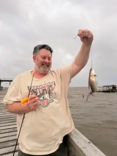
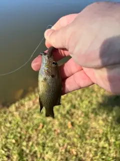
uploaded by: Salim Jamia

uploaded by: rich77

uploaded by: rich77

uploaded by: rich77

uploaded by: Rex_Ursus

uploaded by: bandedwd

uploaded by: Trey Cowan

uploaded by: Trey Cowan

uploaded by: Trey Cowan

uploaded by: Trey Cowan
Best Fishing Spots in the greater Vergennes area
Beaches and Bays are ideal places for land-based fishing. If the beach is shallow and the water is clear then twilight times are usually the best times, especially when they coincide with a major or minor fishing time. Often the points on either side of a beach are the best spots. Or if the beach is large then look for irregularities in the breaking waves, indicating sandbanks and holes. We found 24 beaches and bays in this area.
Fields Bay - 8km , Porter Bay - 8km , Arnold Bay - 9km , Button Bay - 9km , Hawkins Bay - 9km , Kingsland Bay - 9km , Spaulding Bay - 10km , White Bay - 10km , Barn Rock Bay - 11km , Louis Clearing Bay - 11km , Hunter Bay - 12km , South Bay - 12km , Young Bay - 12km , Point Bay Marina - 12km , Town Farm Bay - 12km , Cold Spring Bay - 13km , North West Bay - 13km , Cole Bay - 14km , Whallon Bay - 14km , Converse Bay - 14km , Potash Bay - 14km , Stevenson Bay - 16km , Mullen Bay - 17km , Owls Head Bay - 17km
Harbours and Marinas can often times be productive fishing spots for land based fishing as their sheltered environment attracts a wide variety of bait fish. Similar to river mouths, harbour entrances are also great places to fish as lots of fish will move in and out with the rising and falling tides. There are 3 main harbours in this area.
Porter Bay - 8km, Point Bay Marina - 12km, Champlain Bridge Marina - 19km
We found a total of 88 potential fishing spots nearby Vergennes. Below you can find them organized on a map. Points, Headlands, Reefs, Islands, Channels, etc can all be productive fishing spots. As these are user submitted spots, there might be some errors in the exact location. You also need to cross check local fishing regulations. Some of the spots might be in or around marine reserves or other locations that cannot be fished. If you click on a location marker it will bring up some details and a quick link to google search, satellite maps and fishing times. Tip: Click/Tap on a new area to load more fishing spots.
Vergennes Dam - 0km , Callery Dam - 7km , Stone Bridge Dam - 7km , Fields Bay - 8km , Porter Bay - 8km , Arnold Bay - 9km , Basin Harbor - 9km , Button Bay - 9km , Button Island - 9km , Farrell Dam - 9km , Fort Cassin Point - 9km , Grosse Point - 9km , Hawkins Bay - 9km , Kingsland Bay - 9km , Macdonough Point - 9km , Mile Point - 9km , North Harbor - 9km , Norton Brook Dam - 9km , Ship Point - 9km , Summer Point - 9km , Diamond Island - 10km , Gardiner Island - 10km , Long Point - 10km , Mud Island - 10km , Rock Island - 10km , Spaulding Bay - 10km , White Bay - 10km , Barn Rock - 11km , Barn Rock Bay - 11km , Louis Clearing Bay - 11km , Rock Harbor - 11km , Snake Den Harbor - 11km , Dean Island - 11km , Barber Point - 12km , Bluff Point - 12km , Grog Harbor - 12km , Hunter Bay - 12km , Partridge Harbor - 12km , South Bay - 12km , Young Bay - 12km , Huntington Falls Dam - 12km , Jerome Dam - 12km , Point Bay Marina - 12km , Potash Point - 12km , Thompsons Point - 12km , Town Farm Bay - 12km , Weybridge Dam - 12km , Cold Spring Bay - 13km , Moore Point - 13km , North West Bay - 13km , Split Rock Point - 13km , Brilyea East Dam - 13km , Brilyea West Dam - 13km , Cedar Lake - 13km , Garden Island - 13km , Quinlans Covered Bridge - 13km , Bristol Pond - 13km , Cole Bay - 14km , Cole Island - 14km , Furnace Point - 14km , Rogers Pond - 14km , Whallon Bay - 14km , Beldens Dam - 14km , Cedar Island - 14km , Converse Bay - 14km , Picket Island - 14km , Potash Bay - 14km , Scott Pond - 14km , Tetrault Dam - 14km , Cannon Point - 15km , McNeil Cove - 15km , Oven Point - 15km , Vermont Bridge - 15km , Stevenson Bay - 16km , Elm Point - 16km , Sequin Covered Bridge - 16km , Sloop Island - 16km , Wings Point - 16km , Mullen Bay - 17km , Middlebury Lower Dam - 17km , Owls Head Bay - 17km , Champlain Bridge Marina - 19km , Crane Point - 19km , Fair Bridge - 19km , Holmes Creek Covered Bridge - 19km , Craig Harbor - 20km , Lake Champlain Toll Bridge - 20km , Hill Point - 20km
Comments